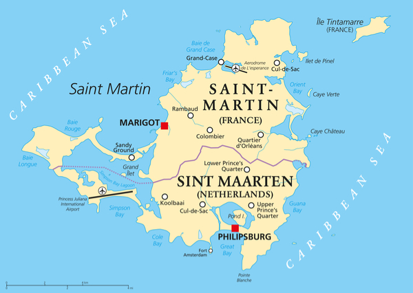
Saint Martin is an island in the Caribbean comprised of two separate countries: the northern French side of Saint-Martin and the southern Dutch side of Sint Maarten. At only thirty-seven square miles, the island is one of the smallest land masses divided between two countries. Saint Martin History In 1493, Christopher Columbus discovered the island […]
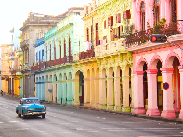
Cuba is a beautiful and mysterious country that presents so much curiosity to tourists worldwide. It is important to embrace both the rural and city experiences for a taste of rich culture and history of the island. And of course, don’t miss out on the beautiful paradise beaches! Below is a rundown of the top […]
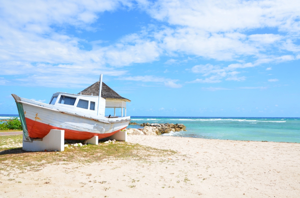
While no resort is far from the water in Jamaica, the resorts listed below are the best luxury, family, couples, and budget beachfront resorts found throughout the island. You will never be unsatisfied or bored at any resort in Jamaica! Half Moon – Montego Bay, St. James, Jamaica (Luxury) Half Moon is a sprawling 400-acre […]
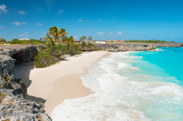
Wherever you go in Barbados, there is a beach waiting with golden sands, turquoise waters and tranquil bays. The beaches of Barbados are varied in which the north coast is considered to be more rugged, with lots of little coves and spectacular views, and the east is similarly choppy, which is great for watersports and […]
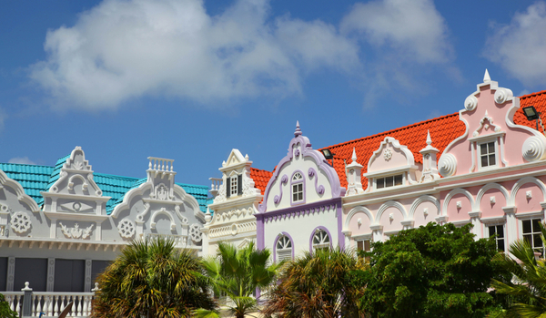
On the small and beautiful island of Aruba, there are endless sites and attractions for tourists to discover. Get to absorb Aruba’s culture, heritage, and natural scenery by visiting historical landmarks or taking a swim in some of the world’s best beaches. Without a doubt, you will experience Aruba’s natural beauty anywhere you go on […]
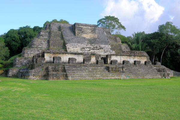
The Mayan Pyramids Belize has a deep history that dates back to the Mayan civilization. Yes, this small country facing the Caribbean was once inhabited by the Mayans. Many of the pyramids built by this great civilization can still be found throughout the country. In fact, one of the largest Mayan artifacts carved from Jade […]
Côte d’Ivoire, or Ivory Coast, is a country in West Africa. It is bordered by Ghana to the east, Liberia to the southeast, and Guinea to the north and northwest. Côte d’Ivoire has an area of 322,463 square kilometers (124,503 square miles). The capital and largest city is Yamoussoukro. The official language is French. Côte […]
Djibouti is a country located in the Horn of Africa. It is bordered by Eritrea in the north, Ethiopia in the west and south, and Somalia in the southeast. The remainder of the border is formed by the Red Sea and the Gulf of Aden at the east. Djibouti’s culture is a mix of French, […]
The Republic of South Sudan is a landlocked country located in East-Central Africa. It is bordered by Sudan to the north, Ethiopia to the east, Kenya to the south, Uganda to the southwest, and the Democratic Republic of the Congo to the west. The country covers an area of 619,745 square kilometers (239,285 square miles), […]
Trinidad and Tobago is an island nation located in the southeastern Caribbean Sea. The country consists of two main islands, Trinidad and Tobago, and several smaller islands. Trinidad is the larger and more populous of the two main islands, with a population of 1.3 million people. Tobago is a smaller island, with a population of […]
The island of Barbados is situated in the eastern Caribbean Sea, and is one of the most popular tourist destinations in the region. The island is roughly rectangular in shape, and it covers an area of about 430 square kilometers. The coastline of Barbados is fairly rugged, with numerous cliffs and rocky outcrops. There are […]
Tonga is an archipelago located in the South Pacific Ocean. It consists of 176 islands, 36 of which are inhabited. The Tongan archipelago is divided into four main groups: Tongatapu, Ha’apai, Vava’u, and Niua. Tongatapu is the largest and most populous island, and it is home to the capital city of Nuku’alofa. Ha’apai is a […]
Samoa is a country located in the central Pacific Ocean. It is made up of two large islands, Upolu and Savai’i, as well as several smaller islands. Samoa has a tropical climate, with warm weather year-round. The Samoa Islands were first settled by Polynesian migrants around 3,000 years ago. Samoa’s culture is strongly influenced by […]
Norfolk Island is an Australian territory located in the South Pacific Ocean. The island is situated about 1,000 miles east of mainland Australia and about 700 miles north of New Zealand. Norfolk Island has a total area of about 35 square miles and is home to a population of just over 2,000 people. The island […]
Niue is an island country located in the South Pacific Ocean. It is about 2,400 miles from New Zealand and about 1,300 miles from Tonga. Niue covers a total area of about 260 square miles, making it one of the smallest countries in the world. Niue has a population of about 1,600 people, most of […]
Kiribati is an island country located in the central Pacific Ocean. It is made up of 33 atolls and reef islands, and has a total land area of about 811 square kilometers. Kiribati is one of the world’s poorest countries, with a per capita income of just US$1, Loa visitors can expect to find a […]
Polynesia is a large grouping of over 1,000 islands in the Pacific Ocean. The Polynesian people are thought to have originated in Southeast Asia, and they began migrating to the Pacific islands around 3,000 years ago. Today, Polynesia is often divided into three main subregions: Micronesia, Melanesia, and Polynesia proper. Polynesia proper is further divided […]
The map of Fiji is both fascinating and perplexing. This small island nation is made up of over 300 islands, many of which are uninhabited. The largest island, Viti Levu, is home to the capital city of Suva as well as the majority of the population. The second largest island, Vanua Levu, is known for […]
The Cook Islands are a group of 15 islands located in the South Pacific Ocean. They are spread over an area of 2 million square kilometers, with a total population of just over 100,000 people. The Cook Islands are renowned for their natural beauty, with white sand beaches, blue lagoons, and lush vegetation. The islands […]
Christmas Island is a small Australian territory located in the Indian Ocean, about 2,600 kilometers northwest of Perth. The island is about 135 square kilometers in size, with a coastline of about 38 kilometers. The island is hilly, with rainforests and cliffs along its coast. Its highest point is Murray Hill, at356 meters above sea […]
Sweden is located in northern Europe, and it is bordered by Norway to the west and Finland to the east. The country covers an area of 173,860 square miles, making it the third largest country in the European Union. Sweden has a population of over 10 million people, and the capital city is Stockholm. Sweden’s […]
Spain is located in southwestern Europe and is bordered by the Mediterranean Sea, the Atlantic Ocean, and Portugal. With a population of over 46 million people, it is the 4th largest country in the European Union. The capital and largest city is Madrid, and other major cities include Barcelona, Valencia, Sevilla, Malaga, and Zaragoza. Spain […]
Norway is a country located in northern Europe, on the western side of the Scandinavian Peninsula. With an area of 324,219 square kilometers, it is one of the largest countries in Europe. Despite its size, Norway has a population of only 5.3 million people, making it one of the most sparsely populated countries in the […]
Netherlands is a country located in northwestern Europe. It is bordered by the North Sea to the north and west, Belgium to the south, and Germany to the east. With a population of over 17 million people, it is the 63rd most populous country in the world. The Netherlands has a total area of 41,543 […]